


Description
View the map in full resolution here
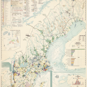
Sweden is still today a country associated with forests and iron, and the same was true a hundred years ago. Swedish iron ore was known for its high quality throughout the Western world, and few other mining countries could match it. Sweden’s earlier core product — copper from the Falun copper mine — has during the same period completely lost its former greatness to the large copper mines of Chile.
The map contains economic information about urban industries such as shoe factories, breweries and coffee roasteries. It also includes information about rural industries — those located outside municipal administration according to Statistics Sweden’s older records (BISOS) — such as sawmills, steel works, glassworks and stone quarries. The map shows several types of flow and trade volumes, including the share of timber floating in the country’s rivers, trade volumes per city and the number of journeys through Sweden’s canals.
What constantly draws me back to the early 1900s is the feeling that the soul and character of many nations and cities took shape precisely then. It is often this period that is highlighted when people speak about a town or place’s history. It is old enough to feel like another world, yet close enough that we can still feel a connection to it.
The traces of this era are often still visible in the form of brick buildings that today house offices, or clear ruins of ironworks and brickworks out in the forests.
It is by understanding this period that one also understands why cities grew where they did — and therefore also a way of understanding Sweden today.
The map is an original work created by myself and can only be purchased from The Age of Trade. The map is free from AI-generated content. Each map takes months to complete, and great effort is put into ensuring that all information accurately reflects the source material.
Width: 500 mm (19.69″) | Height: 400 mm (15.7″) | Margins: 7 mm (0.27″). All information remains visible when framed.
The map has a very high level of detail and is printed on museum-grade Fine Art paper at a local print shop in Leuven, Belgium. The map fits perfectly in IKEA’s 400×500 frames.
- SCB BISOS (1909–1920)
- Sågad Skog för Välstånd (2015) – Ronny Pettersson
- Brukshistoria.se
- Skogsstyrelsen
- Tegelbruk
- Riksdagen

Reviews
There are no reviews yet.