


Description
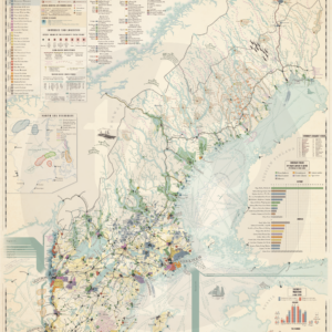
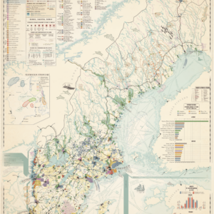
A detailed map of the goods and trade of Meiji era Japan.
In the late 1800’s, Japan found itself in a mix of booming western-style industry and traditional Japanese handicraft and arts. This map captures this dynamic by highlighting trade routes, travel times and the sites of 40 different trade goods, from whaling to silks and umbrellas. It also shows where the finest quality of the goods can be found as well as a list with some of the more famous produce of Japan. It also shows the location of various mines and oilfields.
Read more about trade in Japan here.
MAKING THE MAP
The map is compiled from old travel accounts, contemporary official reports and modern research.
The map is fully original and hand-made by myself.
THE PRINT
Width: 400 mm (19,69″)
Height: 500 mm (15,75″)
Margins: 7 mm (0,27″). Allows for framing without losing information.
Suitable for framing or gluing onto a foam board.
Perfect for affordable 400×500 mm frames, such as from IKEA, as seen in the photos.
The map is printed on high quality thick paper from a local printer in Leuven, Belgium.
SOURCES
William W. Lockwood (1868) The Economic Development Of Japan
Tayui Riuzaburo (1895) Commercial guide and trade directory of Japan
Yoshitaro Takenobu (1905) The Japan year book
J. Morris (1902) Japan and its trade
Eliza Ruhama Scidmore (1891) Jinrikisha days in Japan
Yasuo Takatsuki (2022) The Dojima Rice Exchange


Reviews
There are no reviews yet.