


Description
Click here for the Chinese version
点击此处查看中文版本
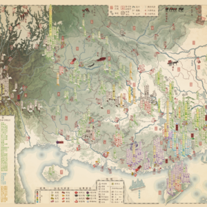
The first map to depict the great tea mountains of China in detail along with old trade routes. It includes over 275 individual tea mountains or notable villages together with the primary tea they produce (Dark, Red, Oolong, Green, Yellow and White tea). The map also contains a list with 94 of Chinas most famous teas, such as Da Hong Pao, Long Jing and Dianhong – with indications of where they are grown. The list comes with a small checkbox next to each tea variety, allowing you to “check off” the teas that you have tried – Can you catch them all?
Dark tea – Dark Tea, and Famously Pu’er tea, is one of the more historically significant teas. It is a fermented tea, and thus ages very well and can handle long journeys. This was therefore the main tea type that was exported overland to neighboring tea drinking areas like Tibet, Central Asia and Russia. Dark tea is often processed into compressed Cakes or Bricks to make it easier to carry. This necessitated special processing centers (featured on the map) that were located on the edge of the Chinese tea growing regions; such as Xiangyang (sending tea to Central Asia), Xiaguan & Ya’an (to Tibet), Hubei centers and Yiyang (to Russia) and Liubao in Guangxi (to Chinese diaspora in South East Asia).
Red tea (or Black tea) – Red tea a fully oxidized (80-100%) tea that was traditionally not popular among the Chinese people. The map features only 19 red tea mountains. Nevertheless it is the most widely consumed type of tea world-wide (about 75% of the market), thanks to the Indian tea plantations. This was the tea that was traditionally sent to Europe and America by the famously fast Clipper Ships.
Oolong tea – Oolong is a semi-oxidized (8-85%) tea with a wide flavor range. It is hands down my favorite type of tea, although I am also very weak for a red Dianhong. Like Green, Yellow and White teas, Oolong teas don’t keep their flavors intact for as long as red and dark teas. It is perhaps therefore that it is traditionally produced in the more metropolitan areas of China, close to the markets. Taiwan almost exclusively cultivate this type of tea due to historical ties with Fujian.
Yellow tea – Yellow tea is a lightly oxidized tea (5-20%). It is by far the most rare type of tea due to the precision needed in order to produce it. If not controlled correctly it was either be spoilt if oxidized for too long or taste like bad green tea if oxidized too lightly. There are only five yellow tea mountains/hills featured on the map – and many of those are based around temple activity.
White tea – White tea is lightly oxidized (0-15%). Unlike the other types of teas it is never roasted and has very delicate flavors. A Baihao Yinzhen (or Silver Needle), even a budget version, is the most soothing and calming tea, if you ask me. What makes white tea particularly interesting is that its cultivation is extremely concentrated in the Fuding area.
Green tea – Green tea has no or very low oxidization level (0-5%). It is traditionally the main tea that is preferred by the Chinese people and it is the most prominent tea featured on this map. It was historically the tea that was consumed more routinely, and thus many villages had their own green tea plantations. Personally, I have yet to learn how to appreciate this tea fully.
MAKING THE MAP
The map is compiled from contemporary official reports and modern research.
The map is fully original and hand-made by myself.
THE PRINT
Width: 500 mm (19,69″)
Height: 400 mm (15,7″)
Margins: 7 mm (0,27″). Allows for framing without losing information.
Suitable for framing or gluing onto a foam board.
Perfect for affordable 400×500 mm frames, such as from IKEA, as seen in the photos.
The map is printed on high quality thick paper from a local printer in Leuven, Belgium.
SOURCES
Sergey Shevelev (2021) Geography of Chinese tea
Adolf Stieler (1925) Map of China (navigable rivers)
The China Sea Directory (1867)
T.T. Cooper (1870) Travels in western China and eastern Thibet
S.W. Williams (1900) The Middle Kingdom


Reviews
There are no reviews yet.